
storm_noaa
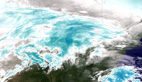
IN SPACE - JANUARY 31: In this GOES-East satellite image from the National Oceanic and Atmosphere Administration (NOAA), a water vapor image shows areas of high atmospheric moisture (colored in shades of blue) of a winter storm as it moves across the midwest area of the U.S. January 31, 2011 from space. According to NOAA, the Midwest and Northeast U.S. are bracing for yet another winter storm to strike Monday into Tuesday. It is expected that this storm may become one of the worst ever to hit Chicago, with blizzard conditions and 15" of accumulation expected. More than 20 states are currently under storm warnings or advisories from the National Weather Service. The New York City region is expecting 2-5" of snow, on top of icing conditions. (Photo by NOAA via Getty Images) Original Filename: 108647298.jpgvia Flatbed Web
Laisser un commentaire
Vous devez vous connecter pour publier un commentaire.